Let’s start with some basic terms and concepts you
should know about surveys
·
Latitude
and Longitude
A geographic coordinate system (GCS) is a spherical or geodetic coordinate system for measuring and communicating positions directly on the Earth as latitude and longitude.[1] It is the simplest, oldest and most widely used of the various spatial reference systems that are in use, and forms the basis for most others.
https://en.wikipedia.org/wiki/Geographic_coordinate_system
·
Metes and
bounds
Metes and bounds is a system or method of describing land, real property (in contrast to personal property) or real estate. Typically the system uses physical features of the local geography, along with directions and distances, to define and describe the boundaries of a parcel of land. The boundaries are described in a running prose style, working around the parcel in sequence, from a point of beginning, returning to the same point; compare with the oral ritual of beating the bounds.
https://en.wikipedia.org/wiki/Metes_and_bounds
· Magnetic Declination
Magnetic declination (also called magnetic variation) is the angle between magnetic north and true north at a particular location on the Earth's surface. The angle can change over time due to polar wandering.
https://en.wikipedia.org/wiki/Magnetic_declination
· Chain (A measurement on some old surveys)
The Surveyor's chain is a measuring device used for land survey. One chain is 66 feet in length and contains 100 links. One link, then, is 1/100 of a chain.
https://en.wikipedia.org/wiki/Chain_(unit)
· Pole or Rod (A measurement on some old surveys)
The rod, perch, or pole (sometimes also lug) is a surveyor's tool[1] and unit of length of various historical definitions. In British imperial and US customary units it is defined as 16+1/2 feet, equal to exactly 1/320 of a mile, or 5+1/2 yards (a quarter of a surveyor's chain), and is exactly 5.0292 meters.
https://en.wikipedia.org/wiki/Rod_(unit)
This old handwritten survey states North 44.75 degrees East for 64 poles
We change the 44.75 bearing to degrees, minutes and seconds and change 64 poles to 1056 feet
In SurveyPlotter, we would enter N
44 45 0 E 1056
How do I use SurveyPlotter?
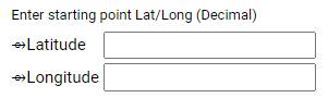
Enter starting point Lat/Long
The starting Latitude and Longitude is the point of your survey that the list of metes (bearings and lengths) start from.
The method we tend to suggest is to take a single point that you know the Latitude and Longitude.
If you have to, use your phone to find that point. Take your time to get the most accurate point you can.
Note: GIS data (from your local government website) is usually pretty inaccurate.
We suggest finding an actual point on the ground, such as an iron pin, yourself, if not already known.
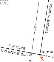
For example, this is a known point from our survey.
IF means Iron Found, usually a piece of rebar driven into the ground.
Refer to the glossary to help determine what you will find on your survey.
This point was found with a phone, walking the property. Let’s say it is Latitude 39.0522 Longitude -78.78077.
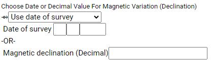
Date of survey
Almost all surveys have a date when it was completed. This date is used to calculate the magnetic declination at the time of a survey. This is caused by the wandering magnetic field of Earth, but we can calculate it. Enter the survey date into the date box. If you happen to know the magnetic declination, you can choose “use decimal declination” from the dropdown and enter it into the Decimal magnetic declination box. You do not need to know this, however, as SurveyPlotter will calculate it from your survey date. We suggest using the date, rather than guessing a declination.
This example survey is July 20th, 2016:
![]()
So I would enter:
For your metes and bounds:
Take each measurement of the perimeter, clockwise (usually), one at a time, and make a list as you move around the perimeter.
In the above example:
My FIRST line is: N 79 07 56 W 213.47
My LAST line is: S 09 00 18 W 330.00
As in this example:
Make sure you don’t have any extra characters. Just one space between each value with no degree marks, quotes, or anything other than letters and numbers (other than a decimal point).
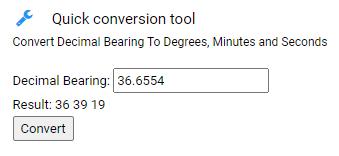
If your
survey shows a decimal bearing
If your survey shows a decimal bearing, such as 36.6554, you may use the Quick conversion tool on the SurveyPlotter page to turn it into degrees, minutes and seconds.
In this example, we convert 36.6554 to 36 degrees, 39 minutes and 19 seconds.
Submitting your survey
Click the Submit button and wait a few seconds:

How to interpret the results

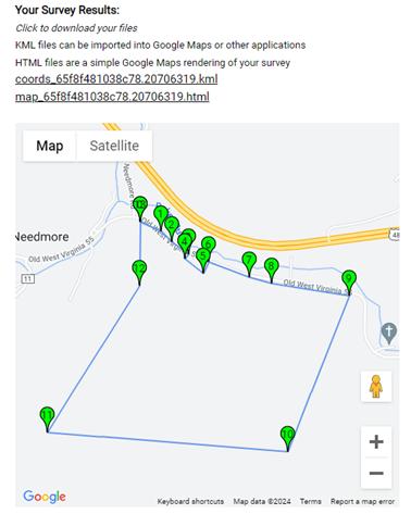
The top part of your results show 2 files.
You can click on either link and your browser should prompt you to save the file locally.
The .kml file can be imported into a layer in your mapping tool. It contains your perimeter points and detail about your survey. Although it can be used in many different mapping applications, we will use Google Maps for simplicity.
Head to Google My Maps: https://www.google.com/maps/d/
Create a new map

Click Import
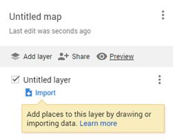
Choose your KML file you saved in the previous step.
Now you can work with your map!
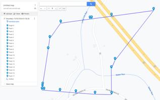
Use it later when you walk your property, use satellite base views to see where your property lines fall, etc.
On your phone, in Google Maps, you can see your saved “My Maps” by choosing Saved, then Maps:

The .html file can be saved and opened in your browser to see a Google Map representation of your survey. Save it somewhere handy for a quick view of your perimeter shape. A small version is shown on your results page for clarity.
Your Data
Below the quick view of your map, you will see the calculated magnetic declination, previously discussed, each of your GPS points corresponding to your metes (each point is listed), and your survey error, which shows you the distance between your first point and your last point (closing your perimeter). If this number is large, you might have entered something incorrectly in your mete list. In this example, our survey closed very well. In our experience, we like to see errors less than 1 foot, however old or difficult surveys might have larger amounts of error.
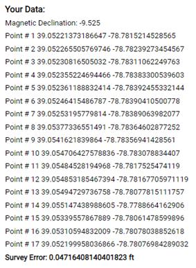
Below this list is a repeat of your starting points and metes you entered in the first step.
Test Data
Test data, if you want to see how things work:
39.0522
-78.78077
07-28-1996
S 56 17 11 E 365.82
S 36 41 22 E 230.57
S 45 4 56 E 333.15
S 44 7 22 W 99.27
S 42 52 37 E 364.41
N 34 45 25 E 197.97
S 60 25 35 E 690.28
S 66 33 36 E 372.19
S 72 23 5 E 1237.1
S 30 19 41 W 2658.39
N 76 26 11 W 3826.52
N 41 10 51 E 2740.93
N 9 30 56 E 1009.33